Over 600 miles of hiking & biking trails have earned us the title of "Best Trail Town" in the Blue Ridge Mountains.

Blue Ridge Parkway Hiking Trails in Virginia
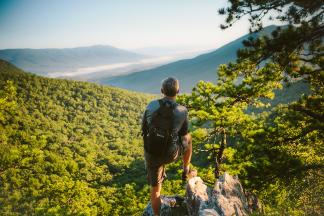
The Blue Ridge Parkway isn't only one of the most scenic drives in the world - it also features many fantastic hiking trails.
When you travel along the Blue Ridge Parkway through Virginia, there are endless opportunities to stop and take in the incredible beauty and peacefulness of the surrounding mountains and valleys.
Many of the hiking trails lead to breathtaking peaks and views that offer a different perspective than what you'll find from staying in the comfort of your vehicle.
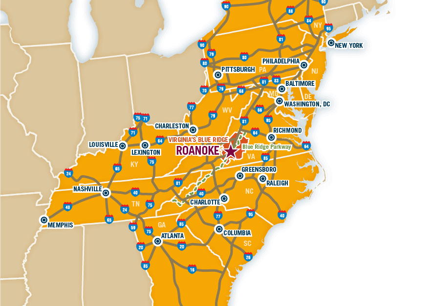
For those with a more adventurous spirit, which is highly encouraged in the Roanoke Valley in Virginia's Blue Ridge Mountains, a hiking trail is a welcome activity when spending time on the Blue Ridge Parkway.
The trails along the Parkway help make up the over 600 miles of hiking trails in Virginia's Blue Ridge!
The following is a list of the hiking trails located on the Blue Ridge Parkway in Virginia.
*Mileage indicates the length of the trail one-way unless otherwise noted.
Milepost |
Trail |
Mileage |
Difficulty |
| 5.9 | Mountain Farm Trail (Self-guiding from Humpback Visitor Center to pioneer farmstead) |
0.25 | Easy |
| 6.0 | Appalachian Trail (Humpback Gap parking area to Humpback Mountain - Elevation: 3,650 feet) |
2.0 | Strenuous |
| 8.4 | Catocin Loop Trail (Leg stretcher) |
0.3 | Moderate |
| 8.8 | Greenstone Trail (Self-guiding; Greenstone geology formation; oak hickory forest) |
0.2 | Moderate |
| 17.6 | The Priest (Scenic view) |
0.1 | Easy |
| 18.5 | White Rock Falls Trail Connection | 2.9 | Moderate |
| 20.0 | White Rock Falls Trail (Follows stream to small falls) |
0.9 | Moderate |
| 26.3 | Big Spy Mountain (Scenic view of the Shenandoah Valley; good for sky watching) |
0.1 | Moderate |
| 34.4 | Yankee Horse (Leads to logging exhibit and small waterfall) |
0.2 | Moderate |
| 38.8 | Boston Knob (Leg stretcher) |
0.1 | Easy |
| 47.5 | Indian Gap (Leads to Indian Rocks; good seasonal rhododendron display) |
0.3 | Moderate |
| 55.2 | White Oak Flats (Leg stretcher) |
0.1 | Easy |
| 60.8 | Otter Creek Trail (Begins at Otter Creek Campground) |
3.5 | Moderate |
| 63.1 | Otter Lake Trail (Around Otter Lake) |
0.8 | Moderate |
| 63.6 | James River Trail (Self-guiding to canal locks) |
0.2 | Easy |
| 63.6 | Trail of Trees Trail (Self-guiding to James River Overlook) |
0.5 | Moderate |
| 74.7 | Thunder Ridge Trail (Leg stretcher loop to view of Arnold Valley) |
0.1 | Easy |
| 78.4 | Apple Orchard Falls Trail (Sunset Field Overlook to view of Apple Orchard Falls) |
1.2 | Strenuous |
| 79.7 | Onion Mountain Loop Trail (Leg stretcher through Appalachian deciduous forest) |
0.1 | Easy |
| 83.1 | Fallingwater Cascades Trail (Loop view of the cascades) |
1.6 | Moderate |
| 83.5 | Flat Top Trail (Leads to the highest of three peaks in the area) |
4.4 | Moderate |
| 85.7 | Abbott Lake Trail (Loop around Abbott Lake) |
1.0 | Easy |
| 85.9 | Elk Run Trail (Self-guiding loop nature trail) |
0.8 | Easy |
| 85.9 | Johnson Farm Loop Trail (Loop to restored farm) |
2.1 | Easy |
| 86.0 | Sharp Top Trail (From camp store to summit of Sharp Top Mountain - Elevation: 3,875 feet; 360-degree panoramic view) |
1.5 | Strenuous |
| 91.0 | Appalachian Trail (VA-695 to Sharp Top Mountain Overlook) |
1.9 | Moderate |
| 92.5 | Appalachian Trail (Sharp Top Mountain Overlook to Harvey's Knob Overlook) |
2.9 | Moderate |
| 95.4 | Appalachian Trail (Harvey's Knob Overlook to Montvale Overlook) |
0.6 | Moderate |
| 95.9 | Appalachian Trail (Montvale Overlook to Taylor's Mountain Overlook) |
1.0 | Moderate |
| 96.0 | Spec Mine Trail (Trail begins near Montvale Overlook to State Rt. 645 in Botetourt County) |
2.8 | Strenuous |
| 97.0 | Appalachian Trail (Taylor's Mountain Overlook to Blackhorse Gap) |
0.8 | Moderate |
| 110.6 | Stewarts Knob Trail (Scenic View) |
0.05 | Easy |
| 114.9 | Roanoke River Trail (Self-guiding river loop) |
0.35 | Easy |
| 120.4 | Roanoke Mountain Summit Trail (Scenic view) |
0.11 | Moderate |
| 120.5 | Chestnut Ridge Trail (Adjacent to Roanoke Mountain campground) |
1.75 | Moderate |
| 121.4 | Roanoke Valley Horse Trail (Begins at US 220 and parallels the Parkway to Milepost 110.6) |
18.5 | Moderate |
| 123.2 | Buck Mountain Trail (Summit view) |
0.53 | Moderate |
| 154.5 | Smart View Loop Trail (Around picnic area) |
2.6 | Moderate |
| 167.1 | Rock Castle Gorge Trail (Loop from campground along ridge over Rocky Knob and into the gorge for a 7-mile return to the campground) |
10.8 | Strenuous |
| 169.0 | Black Ridge Trail (Rocky Knob Visitor Center to Black Ridge to Grassy Knoll and back) |
3.1 | Moderate |
| 169.0 | Rocky Knob Picnic Loop Trail (Leg stretcher) |
1.0 | Easy |
| 176.2 | Mountain Industry Trail (Mabry Mill) |
0.5 | Easy |
| 179.2 | Round Meadow Creek Loop Trail (Walk through stream bottom forest) |
0.5 | Moderate |