Get to know the iconic mountain in Virginia's Blue Ridge where you hike to McAfee Knob.
Appalachian Trail
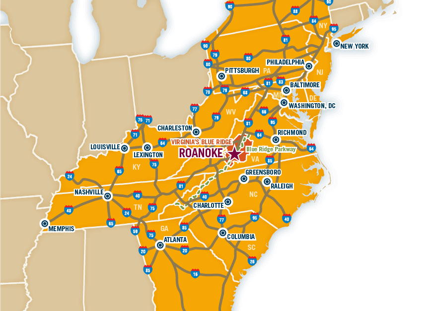
The Appalachian Trail is one of the most iconic scenic hiking trails in the world and it has a number of access points in the Roanoke Valley in Virginia's Blue Ridge.
Roanoke is actually the largest city located along the Appalachian Trail.
At approximately 2,200 miles in length, the Appalachian Trail, or A.T., is revered among outdoor enthusiasts as a challenging and breathtaking path that provides one of the most unique nature experiences on earth.
The northern trailhead is at Mount Katahdin in Maine while the southern trailhead is at Springer Mountain in Georgia.
It is reported to take 5,000,000 footsteps to hike the entire trail and an estimated 2-3 million visitors hike a portion of the A.T. every year.
In Virginia's Blue Ridge, the Appalachian Trail follows a path parallel to Interstate 81 as it winds through large portions of the George Washington & Jefferson National Forest.
Leave No Trace
As one of the most traveled footpaths in the world, we ask that you do your part to help preserve the Appalachian Trail by adhering to Leave No Trace principles while on the trail. Be sure to plan ahead and prepare accordingly for your journey, travel and camp on durable surfaces, properly dispose of waste, leave what you find, minimize the impacts of camping and campfires, respect the wildlife, and be considerate of others on the trail. Learn more on the Leave No Trace website >
Download a full map of the Appalachian Trail from the National Park Service.
Main Entry Points
The following main entry points are from north to south on the A.T.
Blackhorse Gap to Bearwallow Gap
Blue Ridge Parkway - Milepost 90-97
The Appalachian Trail runs parallel to the Blue Ridge Parkway from Milepost 90-97 between Blackhorse Gap and Bearwallow Gap. There are multiple spots along this portion of the road that provide opportunities to hop on the A.T.
Troutville - Route 11
Virginia Route 11 near Exit 150 off Interstate 81
As you travel north on Route 11 from Exit 150 at Interstate 81, the parking lot for this entry point is approximately 3/4 mile from U.S. 220 Alt. and located on the right side of the road. Look for the Appalachian Trail and Troutville signs. The lot also has an A.T. informational kiosk.
Tinker Mountain Road
US 220 at Exit 150 off Interstate 81
There is a gravel parking lot off U.S. 220 beside the Exxon Gas Station. Behind this parking lot is a dirt path that makes its way up the base of Tinker Mountain and connects to the Appalachian Trail.
Catawba Mountain
Virginia Route 311
NOTE: This parking lot is temporarily closed to construct a new pedestrian bridge.
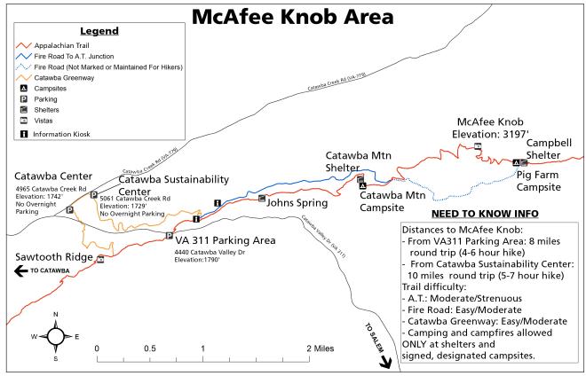
The gravel parking lot at the top of Catawba Mountain on Route 311 is a crossover point for the Trail. This is also the beginning of the popular McAfee Knob trail. To help prevent overcrowding and parking issues at this lot, take advantage of the special McAfee Knob Trailhead Shuttle Service, which operates on Fridays, Saturdays & Sundays - March through November.
You could also consider using the parking lot at the Catawba Sustainability Center (no overnight parking allowed) at 5061 Catawba Creek Road, Catawba, VA 24070. There is a trail from this lot that connects to the Appalachian Trail, which would make for a 10 mile round trip hike to McAfee Knob.
Dragon's Tooth
Virginia Route 311 near Catawba Grocery
The parking lot for the Dragon's Tooth trail off Virginia Route 311 quickly connects with the Appalachian Trail. The nearby Catawba Grocery, which is less than a mile south from the parking lot, is also a great spot for snacks and supplies.
Parking
Hiking on the Appalachian Trail is one of the most popular outdoor activities in Virginia's Blue Ridge, which can lead to overcrowding at many of the parking areas that provide access to the trail. If hiking with a group, please consider carpooling to help limit the number of vehicles in the parking lots.
For hiking to McAfee Knob, visitors are encouraged to utilize the special McAfee Knob Trailhead Shuttle Service >
If possible, consider planning your hikes on weekdays or during off-times to also prevent overcrowding. Please respect all signage and instructions regarding parking, including not parking on private property or along the side of a road.
Shelters
The following is a list of official shelters in Virginia's Blue Ridge with the designated Appalachian Trail waypoint and GPS coordinate information. Mileage decreases from north to south.
- Cove Mountain - Waypoint: CoveMtn1 | 37.51162, -79.65071 | Mile 749
- Bobblets Gap - Waypoint: BobbletsG | 37.46712, -79.70121 | Mile 742.5
- Wilson Creek - Waypoint: WilsonCrk | 37.41935, -79.78558 | Mile 735.2
- Fullhardt Knob - Waypoint: Fullhardt | 37.39852, -79.85366 | Mile 729
- Lamberts Meadow - Waypoint: LambertsM | 37.43461, -79.98754 | Mile 714.6
- Campbell - Waypoint: Campbell | 37.39082, -80.02921 | Mile 708.6
- Catawba Mountain - Waypoint: Catawba | 37.38818, -80.05714 | Mile 706.2
- Johns Spring (Formerly known as Boy Scout Shelter) - Waypoint: BoyScout | 37.38537, -80.07402 | Mile 705.2
- Pickle Branch - Waypoint: PickleBr | 37.38015, -80.1846 | Mile 691.6
Popular Hikes
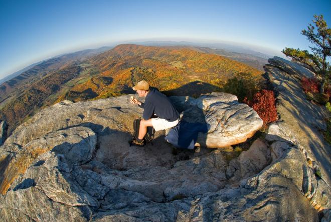
McAfee Knob: one of the most photographed spots of the Appalachian Trail and one of the best views in Virginia's Blue Ridge Mountains. This summit of this hike includes a 270-degree view of the surrounding mountains.
Dragon's Tooth: as one of the tougher hikes in the region, the Dragon's Tooth trail features many unique geological features and offers an incredible view at its summit. Scale the Dragon's Tooth at the summit for a 360-view that will leave you speechless.
Apple Orchard Falls: visit one of the most beautiful waterfalls in Virginia with a hike along the Apple Orchard Falls trail. Much of the trail follows the streams in the area and it culminates at the 200-foot falls.
Triple Crown: combine three of the most popular hikes along the Appalachian Trail in Virginia's Blue Ridge to complete the Triple Crown. McAfee Knob, Dragon's Tooth and Tinker Cliffs are the three segments that make up the crown, and they can also be joined together to create a loop-hike that's also a great overnight backpacking trip.
Roanoke has been named "Best Trail Town" and "Top Adventure Town" by Blue Ridge Outdoors Magazine for its amazing selection of trails. Learn more by viewing our complete list of hiking trails in the Roanoke Region.
Appalachian Trail Map
The above map features key points of interest in Virginia's Blue Ridge, including parking areas, camping shelters, and popular hikes. You can also download this Appalachian Trail map that shows the complete trail.
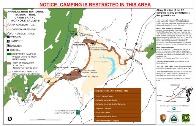
The following map includes details about hiking the Virginia Triple Crown on the Appalachian Trail, which features Dragon's Tooth, McAfee Knob, and Tinker Cliffs.
What's Nearby
There are a variety of activities near the Appalachian Trail, including fantastic options for dining, accommodations and local attractions.
Nearby Salem offers the opportunity to enjoy a Salem Red Sox baseball game, shopping along its quaint Main Street, award-winning craft beer at Parkway Brewing Company, performances at the Salem Civic Center, and plenty of lodging options.
Botetourt County features a great selection of convenient accommodations near the trail, with the Super 8 near Exit 150 off Interstate 81 within walking distance of the base of Tinker Mountain.
The following hotels are also located at Interstate 81 Exit 150, offering easy access to the Appalachian Trail.
- Comfort Inn & Suites Troutville
- Holiday Inn Express Troutville
- Quality Inn Troutville
- Motel 6 Troutville
- Best Western North Roanoke
Botetourt County also offers delicious dining options such as Three Li'l Pigs BBQ, Cracker Barrel, and Town Center Tap House.
Appalachian Trail Conservancy Central and Southwest Virginia Regional Office
416 Campbell Avenue SWRoanoke, VA 24016
(540) 904-4393 (540) 904-4393 Map Details
In This Section
Want the latest on Virginia’s Blue Ridge? Securely sign up for our FREE e-newsletter:
Visit Virginia's Blue Ridge 101 Shenandoah Avenue NE Roanoke, VA 24016 (540) 342-6025 (800) 635-5535
Visit Virginia’s Blue Ridge is committed to cultivating an atmosphere that welcomes and celebrates the unique backgrounds, abilities, passions, and perspectives of our vibrant community. As our region’s only destination marketing organization, we have a responsibility to showcase the best the Roanoke Region has to offer, and those assets and strengths come in varied forms. We embrace differences in race, religion, sexual orientation, gender, gender identity or expression, language, visible and invisible disabilities, and all the intersecting identities that make Virginians and visitors alike so unique. We believe our differences make us stronger– and better.

