
Trip ideas and guides to help you plan the perfect adventure!

-
Things To Do
- Arts & Culture
- Attractions
- Beer, Wine & Spirits
- Blue Ridge Parkway
- Events
- Free Things To Do
- History & Heritage
- Kid Friendly
- Nightlife
-
Outdoor Adventure
- Leave No Trace
- Trail Guidelines
- Appalachian Trail
- Biking
- Climbing
- Disc Golf
- Fall Color Spots
- Fishing
- Geocaching
- George Washington & Jefferson National Forests
- Greenways
- Hiking Trails
- Horseback Riding
- Kayaking & Paddling
- Kid Friendly Outdoors
- Motorcycle Touring
- Outdoor Outfitters & Shops
- Scenic Drives
- Water Sports
- Wildlife Viewing & Birding
- Classes & Workshops
- Sample Itinerary
- Sample Itineraries
- Shopping
- Spas
- Sports
- Tours
- VBR Savings Pass
- Hotels/Lodging
- Restaurants
- Region
- Plan
Search
Roanoke Maps
Maps of Virginia's Blue Ridge
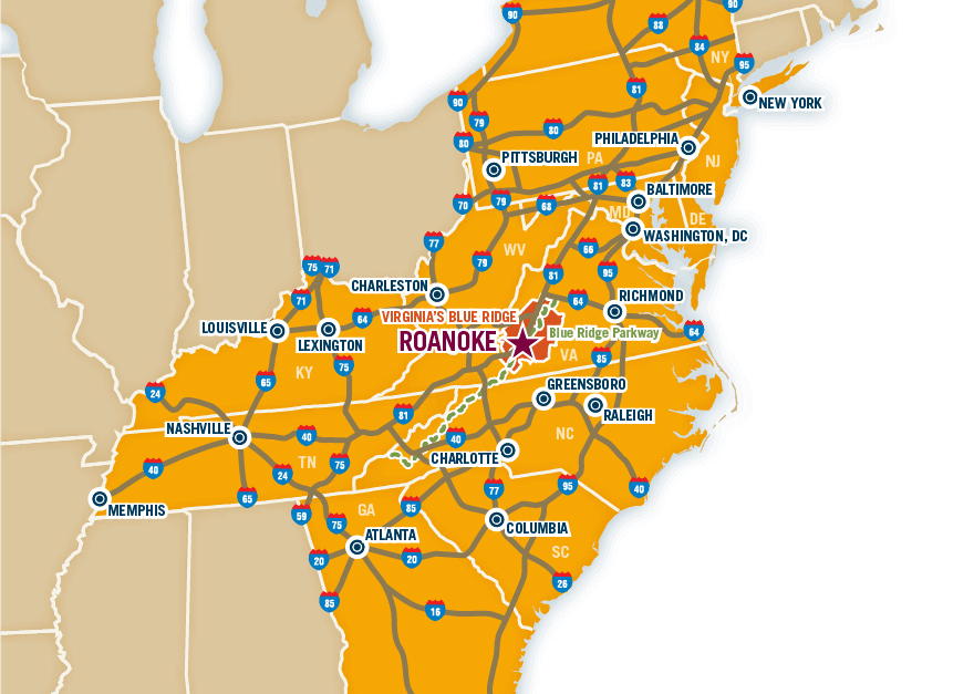
 The following maps of the Roanoke Valley in Virginia's Blue Ridge help provide an idea of where the region is located, in addition to providing great information about where things are located within the region.
Nearby Cities
The Roanoke Valley is within a four-hour drive of many major metropolitan areas, including the following cities:
Greensboro, NC - 104 miles
Winston-Salem, NC - 106 miles
Durham, NC - 165 miles
Richmond, VA - 193 miles
Charlotte, NC - 194 miles
Raleigh, NC - 200 miles
Washington, DC - 251 miles
Knoxville, TN - 261 miles
Baltimore, MD - 281 miles
Norfolk, VA - 284 miles
Columbia, SC - 284 miles
With easy access through Interstate 81, US 220, and the Blue Ridge Parkway, traveling to Virginia's Blue Ridge via car is a comfortable drive.
Need help navigating? Refer to our driving directions.
The region also features outstanding air service through the Roanoke-Blacksburg Airport.
For information about exploring and navigating within the region, these maps offer great detail about many activities and places of interest, including accommodations, attractions, museums, historic spots, and details about other relevant points in the Roanoke Valley.
Interactive Map
You can utilize this Interactive Map of Virginia's Blue Ridge to mark specific points of interest and get more information to help you plan your trip.
Area Maps
-
*Virginia's Blue Ridge Map - the primary map of the region with contact information about hotels, attractions, and various places of interest
-
*Greater Roanoke Valley & Downtown Map - detailed map with information about hotels & attractions in the Roanoke Valley and Downtown Roanoke
-
Roanoke Valley & Downtown Roanoke Maps - printer-friendly map with information about points of interest in the region
-
Blue Ridge Parkway Map - a Google map and page with detailed info about the key entry points for the Blue Ridge Parkway in Virginia's Blue Ridge
-
Downtown Roanoke Dining & Shopping Map - a detailed look at the spots for shopping and dining in Roanoke's Downtown district
-
Downtown Roanoke Parking Map - locate all the public lots and receive information about rates and times with this page and interactive map for parking in Downtown Roanoke
-
Downtown Salem Dining & Shopping Map - a guide to local shops, restaurants and places of interest in Downtown Salem
-
Appalachian Trail Map - a Google map and page with information about access points, camping shelters, and parking for the Appalachian Trail in Virginia's Blue Ridge
-
Roanoke Valley Greenways Map - a Google map and page with information about the extensive Greenway system in the Roanoke Valley, includes spots for parking and specific route segments
*These maps are also available in printed versions in the Roanoke Valley Visitor's Guide. Request your free copy.
In This Section
Roanoke Region Spotlight
Want the latest on Virginia’s Blue Ridge? Securely sign up for our FREE e-newsletter:
Visit Virginia's Blue Ridge 101 Shenandoah Avenue NE Roanoke, VA 24016 (540) 342-6025 (800) 635-5535
Visit Virginia’s Blue Ridge is committed to cultivating an atmosphere that welcomes and celebrates the unique backgrounds, abilities, passions, and perspectives of our vibrant community. As our region’s only destination marketing organization, we have a responsibility to showcase the best the Roanoke Region has to offer, and those assets and strengths come in varied forms. We embrace differences in race, religion, sexual orientation, gender, gender identity or expression, language, visible and invisible disabilities, and all the intersecting identities that make Virginians and visitors alike so unique. We believe our differences make us stronger– and better.

close