- Map View:

-
Things To Do
- Arts & Culture
- Attractions
- Beer, Wine & Spirits
- Blue Ridge Parkway
- Events
- Free Things To Do
- History & Heritage
- Kid Friendly
- Nightlife
-
Outdoor Adventure
- Leave No Trace
- Appalachian Trail
- Biking
- Climbing
- Disc Golf
- Fall Color Spots
- Fishing
- Geocaching
- George Washington & Jefferson National Forests
- Greenways
- Hiking Trails
- Horseback Riding
- Kayaking & Paddling
- Kid Friendly Outdoors
- Motorcycle Touring
- Outdoor Outfitters & Shops
- Scenic Drives
- Water Sports
- Wildlife Viewing & Birding
- Classes & Workshops
- Sample Itinerary
- Sample Itineraries
- Shopping
- Spas
- Sports
- Tours
- VBR Savings Pass
- Hotels/Lodging
- Restaurants
- Region
- Plan
Search
Roanoke River Blueway
-
313 Luck Avenue SW
Roanoke, VA 24011 - Phone: (540) 343-4417 Phone: (540) 343-4417
- FAX: (540) 343-4416
- Visit Website
Click image for larger view
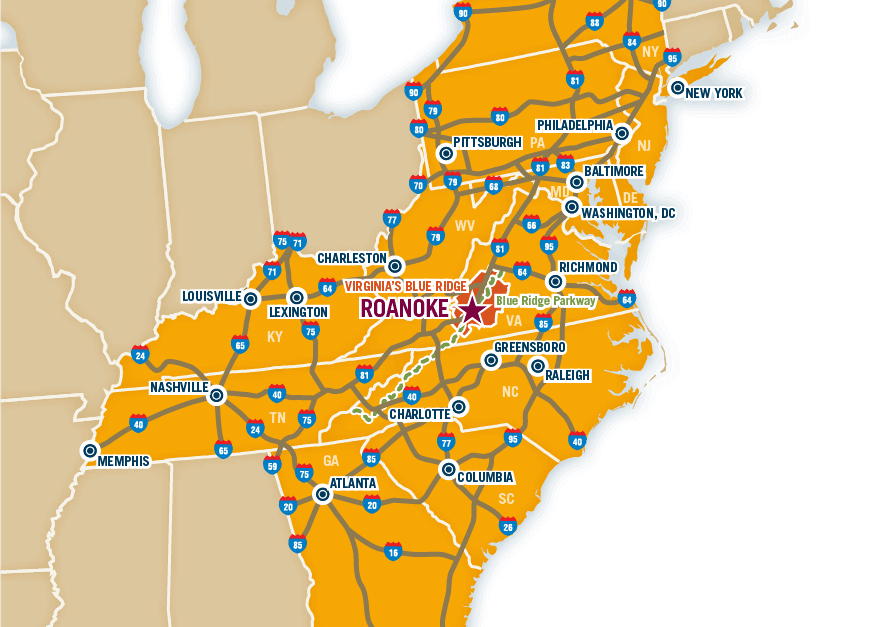
The 45-mile Roanoke River Blueway (water trail) runs from the South Fork Roanoke River at East Montgomery County Park to the Department of Game and Inland Fisheries (DGIF) Hardy Ford boating access at Hardy Road (634) in Bedford County at Smith Mountain Lake. The Roanoke River Blueway includes sections of the South Fork Roanoke River, Tinker Creek, and Back Creek and flows through or borders the cities of Roanoke and Salem, the counties of Montgomery, Roanoke, Bedford, and Franklin, and the Town of Vinton. The Roanoke River Blueway provides river access for canoeing, kayaking, fishing, tubing, wading, wildlife viewing, and other recreational opportunities, while connecting to numerous local parks, Roanoke River Greenway, Tinker Creek Greenway, Mill Mountain Greenway, Blue Ridge Parkway, Explore Park, and Smith Mountain Lake.
Directions
- Directions: For an interactive river map visit: https://www.arcgis.com/home/webmap/viewer.html?webmap=7b70e779fdd24778b2f9311e1d15a8db&extent=-80.2386,37.1691,-79.7315,37.404
Want the latest on Virginia’s Blue Ridge? Securely sign up for our FREE e-newsletter:
Visit Virginia's Blue Ridge 101 Shenandoah Avenue NE Roanoke, VA 24016 (540) 342-6025 (800) 635-5535
Visit Virginia’s Blue Ridge is committed to cultivating an atmosphere that welcomes and celebrates the unique backgrounds, abilities, passions, and perspectives of our vibrant community. As our region’s only destination marketing organization, we have a responsibility to showcase the best the Roanoke Region has to offer, and those assets and strengths come in varied forms. We embrace differences in race, religion, sexual orientation, gender, gender identity or expression, language, visible and invisible disabilities, and all the intersecting identities that make Virginians and visitors alike so unique. We believe our differences make us stronger– and better.

close