There's an adventure and experience for everyone in Virginia's Blue Ridge. Enjoy the ride. Choose your own path. Be a #trailsetter.

Triple Crown Hiking of Virginia
Virginia's Triple Crown - Dragon's Tooth, McAfee Knob & Tinker Cliffs
The Triple Crown is an experience that features some of the best hiking in the Roanoke Region in Virginia's Blue Ridge Mountains.
The three legs of the Triple Crown are:
Map of Key Points for the Triple Crown
Virginia Triple Crown Loop Hike
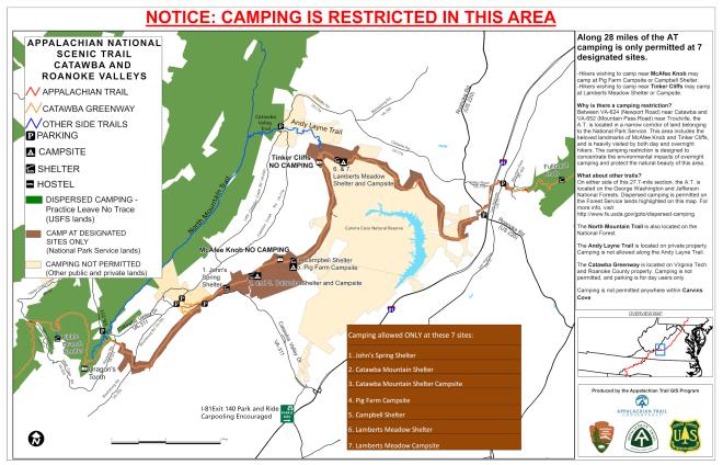
Triple Crown Camping Information
Overview
It provides hikers and outdoor enthusiasts the opportunity to conquer three of the region's most popular trails and encounter some of our most spectacular views. It can be completed over multiple trips to Virginia's Blue Ridge, or for the avid adventurer, there's the option to create a 32-mile loop that could be completed over the course of multiple days.
During this portion of the Appalachian Trail, hikers will be rewarded with incredible overlooks, unique rock formations that create opportunities for bouldering, shelters for a rustic camping experience, and challenging trails that you can check off your bucket list!
Keep reading for more information about each segment of the Triple Crown.
Leave No Trace
Please adhere to Leave No Trace principles to help ensure the Virginia Triple Crown remains an enjoyable hiking experience for locals and visitors for years to come.
Protecting the natural environment and maintaining its beauty is an essential part of what makes the Appalachian Trail and Virginia's Blue Ridge an amazing destination.
Learn more by visiting the Leave No Trace website >
Parking & Crowds
In addition to respecting Leave No Trace principles, we also ask that you schedule and plan your hikes responsibly. The Triple Crown features three of the most popular hikes in Virginia, which leads to issues with overcrowding in the parking lots and along the trails.
For hiking to McAfee Knob, visitors are encouraged to utilize the special McAfee Knob Trailhead Shuttle Service, which operates Fridays, Saturdays, and Sundays from March through November. Shuttle Service Information & Tickets >
NOTE: The McAfee Knob Trailhead Parking Lot will be closed from November 2023 through late 2024 due to construction of a new pedestrian bridge. Parking lot closure info & alternatives >
If hiking with a group, we strongly encourage you to carpool to limit the number of vehicles in the designated parking areas at the trailhead.
And if possible, we recommend hiking during weekdays or at off times to help avoid large crowds.
Remember to park only in designated parking lots - cars parked along the side of the road and in undesignated areas will be towed.
Virginia Triple Crown Loop
One option for experiencing the three summits of the Virginia Triple Crown is by hiking the Triple Crown Loop, a difficult hiking and overnight backpacking trip that totals 35 miles. It takes approximately 3 days to complete (2 nights of camping) and the loop includes making the climbs to Dragon's Tooth, McAfee Knob, and Tinker Cliffs, and it begins and ends at the Route 311 Appalachian Trail trailhead.
Please note that this is a challenging hiking experience and plan accordingly by bringing plenty of water, food, and proper footwear and camping equipment. Also, camping along this portion of the Appalachian Trail is only allowed at designated campsites, so please respect the guidelines and do not camp in restricted areas.
Learn more about the Virginia Triple Crown Loop >
Virginia Triple Crown Map
The following is a helpful map that can serve as a resource for hiking the Triple Crown, with information about camping shelters, parking lots, and where each summit is located.
Begin your adventure at the Dragon's Tooth Parking Area off Route 311.
Dragon's Tooth
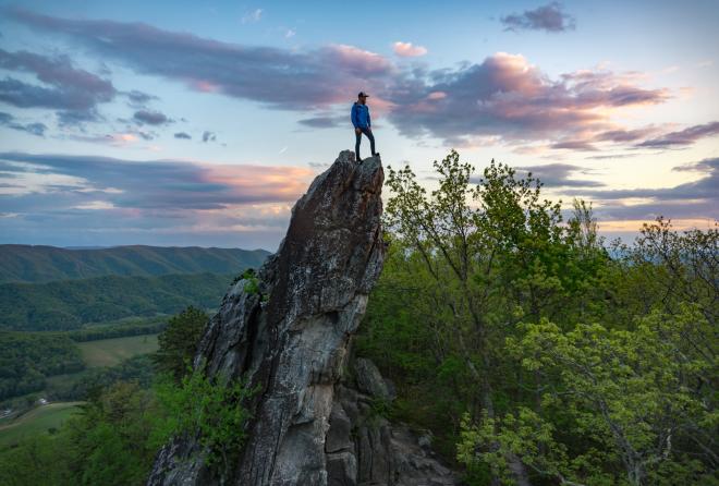
Don't be fooled by the fact the hike to Dragon's Tooth is only 2.3 miles (4.6 out-and-back). The first 1.5 miles of this journey wind along streams and easily identified, well-marked trails, but then you'll be tested by the climbing and steep ascent to the top. The final 0.8 miles of the hike will test your bouldering skills and make use of iron climb bars in place to assist as you make your way up rock walls.
At the top, the climb pays off with a stunning view of Virginia's Blue Ridge Mountains on the horizon. For an even more unique view, climb to a spot on "The Tooth" - a 35-foot tall quartzite rock spire that reaches into the sky.
Trail Info: Hiking Upward - Dragon's Tooth Trail Guide >
Post Hike Food: Allsports Cafe - Salem | Post Hike Beer: Parkway Brewing Company
Loop Option
If you're hiking the entire portion of this stretch of the trail, continue north on the Appalachian Trail for 7.5 miles until you reach the McAfee Knob Parking Lot, which officially begins the second leg. The alternate option is to return to the Dragon's Tooth Parking Lot and drive south on Route 311 for 4 miles until you reach the McAfee Knob Parking Lot.
McAfee Knob

McAfee Knob is one of the icons and most recognizable points along the entire Appalachian Trail, as well as the most popular hike in Virginia's Blue Ridge.
The pronounced rock ledge that defines McAfee Knob provides a stunning 270-degree panoramic view that can serve as the perfect setting to watch the sunrise. It's also where hikers capture breathtaking photos of people standing and sitting on the edge of the mountain.
Learn more about the iconic Catawba Mountain where McAfee Knob is located >
It's a moderately difficult hike that takes approximately 4-6 hours if you do the out-and-back trip from the McAfee Knob Parking Lot off Route 311. You could also begin your hike at the Catawba Sustainability Center (5061 Catawba Creek Road | day-use parking available/no overnight) and complete the approximately 10-mile round trip hike.
To avoid dealing with finding a parking spot at the crowded trailhead lot, take advantage of the special McAfee Knob Trailhead Shuttle Service, which operates Fridays, Saturdays, and Sundays from March through November.
Trail Info: Roanoke Appalachian Trail Club - McAfee Knob Trail Map >
Post Hike Food: Mac and Bob's Restaurant | Post Hike Beer: Olde Salem Brewing Company
Loop Option
If you're completing the Triple Crown in one trip, you'll opt to continue north on the Appalachian Trail instead of making your way back to the parking lot. From McAfee Knob, it's approximately 5.5 miles to Tinker Cliffs along the trail.
Tinker Cliffs

If there's a hidden gem of the three segments of the Triple Crown, it's Tinker Cliffs.
Following the Andy Layne Trail off Catawba Road, this 7.7-mile out-and-back hike will test your strength as the trail features nearly 2,000 feet of elevation gain.
Once you reach Tinker Cliffs, which are made from limestone that's over 250 million years old, stand in awe of the Blue Ridge Mountains to your south, which includes Catawba Mountain and McAfee Knob. From an elevation of 3,000 feet, it's an amazing view.
Note - a portion of this hike winds through private property so please respect all signage and stay on the trail.
Trail Info: Hiking Upward - Tinker Cliffs & Andy Lane Trail >
Post Hike Food & Drink: Town Center Tap House | Angelle's Diner | Three Li'l Pigs Barbeque
Loop Option
For those completing the Triple Crown as a loop, once you reach Tinker Cliffs, you continue north on the Appalachian Trail until turning left onto Andy Layne Trail. Follow this trail until you reach the parking lot at Route 779 and cross the road to connect with the yellow-blazed North Mountain Trail.
Turn left and head south on the trail along the ridge of North Mountain until you reach Route 311. Turn left and hike south on Route 311 until reaching the Dragon's Tooth Parking Lot to complete the loop.
Camping
Camping is prohibited on McAfee Knob and Tinker Cliffs. There are numerous camping shelters along this portion of the Appalachian Trail in Virginia's Blue Ridge. Please camp only in designated spots along the trail. These have been marked on the Triple Crown Map.

The four designated camping shelters located along this route are:
- Campbell
- Catawba Mountain
- Johns Spring
- Lamberts Meadow
Other Resources
Visit our Hiking section to learn more about the outstanding trails in Virginia's Blue Ridge, including our list of 10 Great Trails. You might also like visiting our 7 Natural Wonders of Virginia's Blue Ridge!

More Outdoor Fun
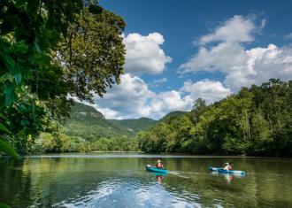
Upper James River Water Trail in…
In the glory of Virginia’s Blue Ridge, you’ll find the breathtaking Upper James River Water Trail.

Spring Fun in Virginia's Blue Ridge
Spring is here! The weather has been variable so far this March, but there have been some really
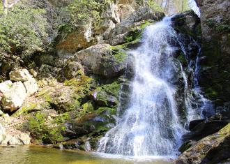
Waterfall Weekend Itinerary for…
Waterfalls are a favorite draw for most anyone, outdoor explorer or not. They seem to make us happy,

Top Sights on the Blue Ridge Parkway
The non-commercialized 469-mile Blue Ridge Parkway begins in Waynesboro, Virginia, and stretches all

Ideas for a Weekend on a Budget in…
Sometimes you need a little getaway. Not an over-the-top trip, but a weekend scoot that won’t break
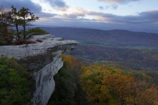
Get to know the iconic mountain in Virginia's Blue Ridge where you hike to McAfee Knob.