
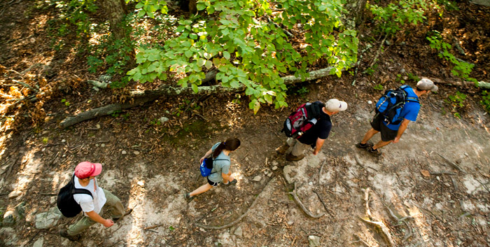
Appalachian Trail Hikes
The Appalachian Trail is a 2,175-mile trail following the Appalachian Mountains from Georgia to Maine, with 120 miles of the trail winding through the Roanoke Region. The A.T. offers dozens of short and long hikes, easy to strenuous. Throughout the region you can find trail loops that peak at waterfalls and cliffs, always promising spectacular views.
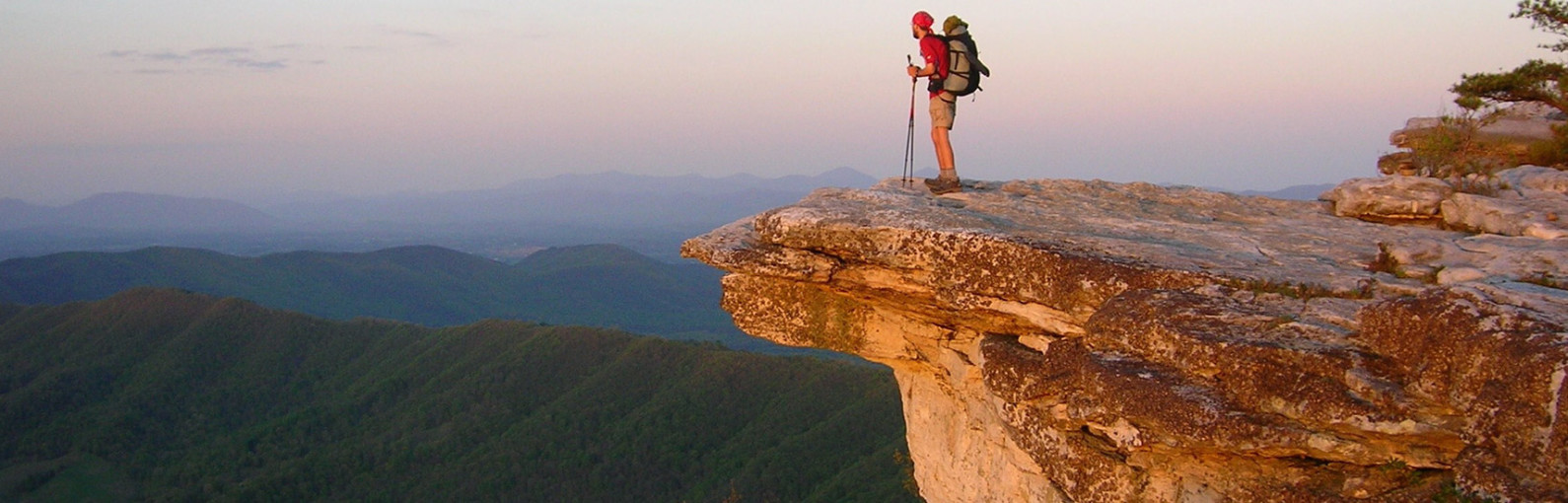
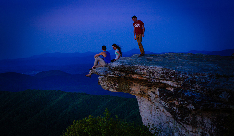
One of the highlights of the trail in the Roanoke Region is McAfee Knob, the most photographed point along the trail. It is also prominently featured in the 2015 movie, “A Walk in the Woods,” starring Robert Redford.
Plan An Overnight Hike
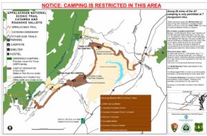
The A.T. offers a great opportunity for overnight backpacking trips. Shelters, which are typically three-sided structures that allow you to camp without a tent, are spread along the trail at varied intervals which allow you to hike at your own pace. An interactive Appalachian Trail map shows shelters, parking lots, and vistas along the A.T.
Find Your Hike
Appalachian Trail Hikes
-
Angel’s Rest


 The climb to Angel’s Rest above Pearisburg is notorious among Appalachian Trail hikers for its punishing incline. You must endure a 1.5-mile, 1,650-ft. climb before you can sprawl over a boulder enjoying the view of the New River. The hike is 4.6 miles round trip.
The well-worn trail leads into a spring-fed ravine and briefly along an old logging road before settling into a consistent, thrashing course of switchbacks. The path crosses over two ancient rockslides and passes through thick poplar and oaks, as well as laurel and rhododendron.
Gradually, the thriving hardwood forest of the lowlands gives way to stunted oaks and shrubs. When you reach the boulders at the top, detour a few hundred feet to the right on a blue-blazed trail for a view of Pearisburg and the twisting New River. The A.T. continues to the crest of Angel’s Rest and follows along a rock ledge overhanging Wilburn Valley for spectacular views.
-
Apple Orchard Falls
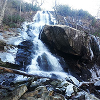 Apple Orchard Falls is one of Virginia’s tallest and most spectacular waterfalls. Singing streams, dancing down cascades, huge boulders, and thick stands of forest surround stunning vistas and towering bluff lines. The 7.5-mile loop trail is moderately difficult.
Apple Orchard Mountain was named for the nature of the dominant northern red oak forests on its summits and ridges. The weather is so severe on the upper elevations of the mountain that the trees have taken on a stunted appearance, as if they have been trimmed and pruned over the decades.The Appalachian Trail and the Blue Ridge Parkway pass within a short distance of the top of Apple Orchard Mountain.
-
Balcony Falls Trail
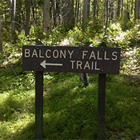 The Balcony Falls Trail begins at the Locher Tract parking area and follows an old road through the Locher Tract for 3.78 miles.
Off this old road, the trail turns right and meanders with a gentle climb through the woods along another old road. Upon approaching the James River Face Wilderness boundary, the trail begins a more sharp ascent over a series of switchbacks with panoramic views of the James River. The trail becomes easier at approximately 2,200 feet with a gentle climb along the ridgeline with scenic views to the east and west.
-
Devil’s Marbleyard
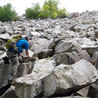 Devil’s Marbleyard includes a steep incline for most of the trip, but is well worth the time. The trail is not marked well, but you can follow the blue blazes until the end of the Belfast Trail. Then continue to follow the trail.
The hike itself is not that long, about 45 minutes, but you will definitely want to plan time to stay at the marbleyard and explore.
Devil’s Marbleyard is a boulder field, with many rocks that are the size of a car. The Antietam Quartzite found at the site is the result of a rise in sea level relative to the land that occurred over 500 million years ago. The boulders have tube-like structures running along them that are believed to be fossilized cavities where worm-like creatures lived.
-
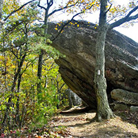
Dragon’s Tooth
Dragon’s Tooth is a unique geologic feature that consists of
 Tuscarora quartzite spires which outcrop on the top of Cove Mountain. The tallest “tooth” projects roughly 35 feet above the surrounding rock. The trail to Dragon’s Tooth ascends steep, rugged outcrops of quartzite which form the spine of Cove Mountain and North Mountain. The spine is known as Dragon’s Back.
Note: The Dragon’s Tooth hike is one of the most popular hikes along the entire Appalachian Trail and sees a tremendous amount of hiker traffic. The trailhead parking lot (Rt. 311) has limited space; DO NOT PARK on Rt. 311 – YOU WILL BE TOWED. It is ideal to hike this on a weekday as weekends are very crowded. Vehicles not parked in the parking lot are subject to tow. Please read specific rules and regulations at the bottom of this description.
Hike Description
- ~ 4.5 mile round trip, out and back hike.
- Moderate to difficult.
- 20 minutes from downtown Roanoke.
- Map kiosk at trailhead (very straight forward hike). Take a picture of the map so you have it on your phone.
- The trail starts with a kiosk at the back of the parking lot. You will follow the blue-blazed trail to the very top.
- Go 0.25 mile and cross two small bridges.
- You’ll see the intersecting yellow-blazed Boy Scout Connector Trail. Bear right and continue on the blue-blazed trail.

- Continue for nearly 1.5 miles, crossing the creek several times on a steady incline before reaching the Appalachian Trail intersection.
- Turn right to go south on the white-blazed Appalachian Trail. There will be 0.7 miles of steep rock steps before bearing left at the intersection to follow the blue-blazed trail to Dragon’s Tooth.
- Come back the way you went up, or once you reach the Appalachian Trail, go beyond the blue-blazed trail you started on and continue north on the A.T. until you reach the yellow-blazed Boy Scout Connector Trail. You’ll go left on this trail until you reach the blue-blazed Dragon’s Tooth Spur Trail, and go right toward the parking lot. This second route back offers different scenic views.
Directions to Trail Head
- From Roanoke – take I-81 south to Exit 141. Turn left at the traffic light onto Rt. 419 (Electric Rd.) and follow 0.4 miles to next traffic light (Rt. 311). Turn right onto Rt. 311N and follow for 10 miles. Dragon’s Tooth parking lot is on left just past Catawba Grocery.
Rules & Regulations
- Max. group size for day hikes is 25 people.
- Max. group size for backpacking/camping is 10 people.
- No alcohol
- Bring lots of drinking water
- Bring a flashlight as groups often lose track of time and are hiking back in the dark
- Dogs must be on leash at all times (be aware there is a section where you will have to lift your dog up a 6′ wall)
- No camping or campfires on Dragon’s Tooth, McAfee Knob or Tinker Cliffs
- Practice Leave No Trace
- Pack out all trash
- No camping or campfires outside of the 7 designated shelters/camping areas.
- Visit local A.T. C. Club for more details.
Add On
- Finish your day with a great meal at the Home Place – a restaurant famous among thru hikers. To reach the Home Place, continue north on Rt. 311 for ~1 mile to a large white farmhouse on left.
- Grab a beer at Parkway Brewing Co.
- Go see a baseball game! Click here for Salem Red Sox schedule
-
James River Wilderness Trail
A 21.9-mile section of the Appalachian Trail that parallels the James River. This moderately strenuous trail overlooks the James River Water Gap and offers multi-day hiking and camping options.
This is a challenging hike and requires some logistics in setting up a car shuttle because it is a one-way hike on the A.T. Leave a car at the James River Foot Bridge A.T. parking lot then drive to the Blue Ridge Parkway on Route 501 and head south to Sunset Field (MP 78.4) for the second car.
-
Kelly Knob
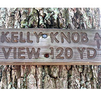 A 6.6 mile, out and back hike on the Appalachian Trail, Kelly Knob is located on a ridge that bridges the valley between John’s Creek Mountain and Clover Hollow Mountain and is immediately off of the Appalachian Trail. While Kelly Knob is not the highest point on the ridgelet (the high point is densely wooded), it is still much higher than its mountain neighbors with a fantastic vista of the New River Valley.
A shorter option (4 miles round trip) approaches Kelly Knob from the opposite direction.
Sandstone bedrock forms a broken escarpment along the east and south of the ridge, and the area around Kelly Knob is particularly striking with 50 foot cliffs containing deep fissures in the rock. The trails to Kelly Knob are well signed and traveled.
-
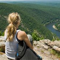
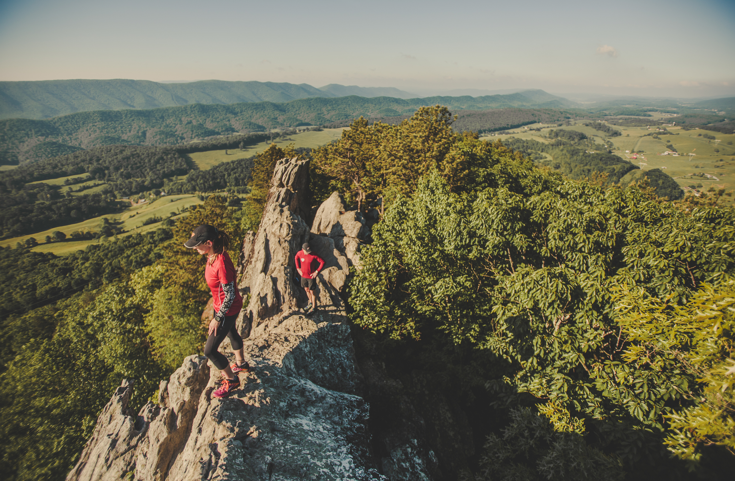
McAfee Knob

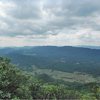
McAfee Knob is the most photographed site along the Appalachian Trail. The knob has an almost 270-degree panorama view of the Catawba Valley and North Mountain to the west, Tinker Cliffs to the north and the Roanoke Valley to the east.
UPDATE: The trailhead parking lot on Rt. 311 will be fully (as in 100%) closed for 12 months, beginning 11/30/2023, while construction of a pedestrian bridge across Rt. 311 is built. Only the parking lot will be closed, the Appalachian Trail will remain open. Click here for a list of alternative parking options. You will be ticketed/towed if you park along Rt. 311. Carpooling is recommended.
Note: The McAfee Knob hike is one of the most popular hikes along the entire Appalachian Trail and sees a tremendous amount of hiker traffic. DO NOT PARK on Rt. 311 – YOU WILL BE TOWED. It is ideal to hike this on a weekday as weekends are crowded. Click here for a list of alternative parking options.
McAfee Knob Trailhead Shuttle: Avoid parking headaches by utilizing the McAfee Knob shuttle service. This seasonal shuttle runs every Friday, Saturday, and Sunday, with the occasional holiday Monday. The 2024 shuttle season runs March 1, 2024 through November 26, 2024. The shuttle departs every 30 minutes from Park & Ride at I-81 Exit 140. New for 2024, additional on-demand shuttle stops include downtown Salem, Orange Market, and Dragon’s Tooth trailhead – Learn more and reserve your spot.
Trail Description
McAfee Knob is one of three hikes that make up the Appalachian Trail Triple Crown in Virginia. This overnight backpacking trip begins and ends at the Route 311 Appalachian Trailhead. This is a difficult hike totaling about 32 miles and includes McAfee Knob, Tinker Cliffs, and Dragon’s Tooth.
- Approximately 7.5 miles round trip.
- Allow 4-6 hours for full roundtrip hike.
- The trail begins on the opposite side of Rt. 311 from the parking lot. Cross Rt.311 with caution. You will travel north on the Appalachian Trail on to McAfee Knob. Follow the white blazes – which are 6-inch rectangular paint marks placed periodically on trees at eye level.
- After ~0.3 miles you will come to an informational kiosk.

- You will cross four wooden walkways before reaching the Johns Spring shelter. You will then cross five more wooden walkways before reaching the Catawba Mountain shelter.
- Next, you will cross an old fire road and a power line clearing. Continue 0.5 miles further and turn left onto the McAfee Knob spur trail to arrive at the lookout in ~30 yards.
- Retrace your steps or turn right once you reach the alternate fire road for your return trip.
Rules & Regulations
- Maximum group size for day hikes is 25 people
- Maximum group size for backpacking/camping is 10 people
- Bring lots of drinking water
- Bring a flashlight as groups often lose track of time and are hiking back in the dark
- Dogs must be on a leash at all times
- No camping or campfires on McAfee Knob or Tinker Cliffs
- Practice Leave No Trace
- No camping or campfires outside of the seven designated shelters/camping areas
- Visit local A.T. Club for more details
Directions to Trailhead
From Roanoke – take I-81 south to exit 141. Turn left at the traffic light onto route 419 (Electric Rd.) and follow 0.4 miles to the next traffic light (Rt. 311N). Turn right onto Route 311N and follow 5.6 miles to the top of the mountain. The trailhead parking lot is at the very top on the left. Be careful turning into the parking lot as it is a semi-blind turn. Do not park on the side of Rt. 311, you will be ticketed and towed.
Add-on Adventures
- Grab a post-hike beer at Parkway Brewing Co.
- See a baseball game! Click here for the Salem Red Sox schedule.
-
Mountain Lake Conservancy
 The Mountain Lake Conservancy manages 2,600 acres of mountainous terrain that encompasses a unique ecosystem due to an average elevation of more than 4,000 feet.
More than 20 miles of fern-lined trails on the property are open to the public for biking year-round. The trails are home to the “Dirty Dawg MTB Race” and offer trail options for all experience levels. Mountain bike rentals are available at Mountain Lake Hotel.
-
Tinker Cliffs (Andy Layne Trail)
The 6.6-mile out and back hike on the Andy Layne Trail intersects with the Appalachian Trail and ends with incredible views.
From the trailhead, take the yellow-blazed trail for about 3.1 miles to the intersection with the Appalachian Trail. Turn right onto the white-blazed A.T. (southbound) and reach Tinker Cliffs within 0.75 miles. Enjoy the 180 degree view.
From 1,300 feet near the trailhead and creek crossings to just a hair under 3,000 feet at the cliffs. Bluff top views are the most prominent feature, but there are also nice creek drainages, intriguing rock formations, and lovely forests on the way. Even the part of the trail that goes through a cow pasture includes pleasant rushing streams and scenic views up toward surrounding ridges. Some tough, steep stretches as it rises 1,700 feet in elevation.
-
Tinker Ridge/Hay Rock Overlook
 Tinker Ridge Trail crosses Tinker Creek, which is the site depicted in Annie Dillard’s “Pilgrim at Tinker Creek,” then ascends Tinker Ridge at Hay Rock Overloook, providing spectacular views of Carvins Cove and the Roanoke Valley.
The 8-mile round trip hike on the Appalachian Trail is just 15 minutes from Downtown Roanoke and is of moderate difficulty.
-
Virginia Triple Crown Loop
The Triple Crown is a combination of three amazing hiking destinations in Virginia. And they’re all conveniently located right around Roanoke. This overnight backpacking trip begins and ends at the Route 311 Appalachian Trail head. This is a difficult hike totaling about 32 miles.
Click for detailed view.
There are several options for hitting the Triple Crown. There are shuttle systems that will transport you from trailhead to trailhead. You can also take advantage of the Appalachian Trail and hike your way between the trails on the Virginia Triple Crown Loop. The conditions for backpacking are subject to change. Stay updated before your trip and check in with the Roanoke Appalachian Trail Club.
Up for the challenge? We broke it down for you.
McAfee Knob
The most photographed site on the Appalachian Trail includes a nearly 270-degree panorama of Catawba Valley, Tinker Cliffs, and the Roanoke Valley. NOTE: the McAfee Knob trailhead parking lot on Rt. 311 is closed during 2024 while a pedestrian bridge is built across the highway. Learn more and plan accordingly.
- Where: Off Route 311
- Length: 8 mile round trip (out and back hike)
- Difficulty: Moderate (gradual uphill on way up, downhill on return)
- Estimated time: Plan for at least 5 hours
- WARNING: Only park in the trail head parking lot off Rt. 311. DO NOT park on the side of Rt. 311 – you will be towed.
- View Overview Map
- Map and directions
Breakdown: Beginning opposite of the parking lot off Route 311, you join the Appalachian Trail and head north toward the Knob. There’s an informational kiosk about 0.3 miles in. Follow the white blazes (rectangular
paint marks on the trees) to stay on the right path. You’ll cross four wooden walkways and see the Johns Spring shelter. Then you’ll cross five more and pass the Catawba Mountain shelter. Next, cross an old fire road and power line clearing. Walk for another 0.5 mile and turn left on the McAfee Knob spur trail to arrive at the lookout. Come back the way you went up.Insider Tips:
- Parking fills up quickly, and you can’t park on the shoulder of Route 311. Your best bet to guarantee parking is to visit on a weekday or before 8 a.m.
- Another option for larger groups is to stop at the I-81 Exit 140 Park and Ride (click on the green car right by the ‘R’ in Roanoke on the map for directions) and carpool to the trailhead.This hike is lengthy and not to be underestimated, despite being considered the “easier” of the three Triple Crown hikes.
Tinker Cliffs/Andy Layne Trail
 Streams, creek drainages, rock formations, and lush forest offer pleasant views on the hike up, which rises 1,700 feet in elevation. Bluff top views at the peak with a 180-degree panoramic view are spectacular.
- Where: Off Route 779 (Catawba Road)
- Length:7 miles (out and back hike)
- Difficulty: Difficult (lengthy with steep elevation gain)
- Estimated time: 4-5 hours
- Map and directions
Breakdown: You’ll start off of Catawba Road and follow the yellow-blazed Andy Layne Trail. You will cross two fence stiles, then two Catawba Creek bridges. Continue as trail bears left, then right after 100 feet. The hardest part of the hike includes a steep elevation gain with some areas of no switchbacks (zig-zagging). Three miles in, you will join the Appalachian Trail (white blazes). Continue and you will see a view of Broad Run Mountain. Next, you will reach a view of the Catawba Valley. The better view is 200 yards beyond this first view, with McAfee Knob clearly visible. Come back the way you went up.
Insider Tips:
- Stay on the trail – the area around the trail is private and belongs to Roanoke Cement Company.
- The trail gets steep in places, so be prepared.
- Explore the cliffs once you reach the top!
Dragon’s Tooth
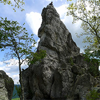 Tuscarora quartzite spires that outcrop on the top of Cove Mountain are the distinguishing feature with the tallest “tooth” projecting about 35 feet above the surrounding “teeth.” The trail ascends the spine of Cove and North Mountain, called “Dragon’s Back” because it is composed of steep rock.
- Where: Off Route 311, past Catawba Grocery
- Length: 5 mile round trip (out and back hike)
- Difficulty: Moderate to difficult (not lengthy, but steady incline that leads to a steep, rugged section)
- Estimated time: Plan for at least 4 hours
- Map and directions
Breakdown: The trail starts with a kiosk at the back of the parking lot. You will follow the blue-blazed trail to the top. Go 0.25 mile and cross two small bridges. You’ll see the intersecting yellow-blazed Boy Scout Connector Trail. Bear right and continue on the blue-blazed trail. Continue for nearly 1.5 miles, crossing the creek several times on a steady incline before reaching the Appalachian Trail intersection. Turn right to go south on the white-blazed Appalachian Trail. There will be 0.7 miles of steep rock steps before bearing left at the intersection to follow the blue-blazed trail to Dragon’s Tooth. Come back the way you went up, or once you reach the Appalachian Trail, go beyond the blue-blazed trail you started on and continue north on the A.T. until you reach the yellow-blazed Boy Scout Connector Trail. You’ll go left on this trail until you reach the blue-blazed Dragon’s Tooth Spur Trail, and go right toward the parking lot. This second route back offers different scenic views.
Insider Tips:
- Take a picture of the map at the kiosk, or bring your own. Despite new signs and a well-marked trail, people can still get lost on the way back down.
- This hike is considered to be harder than McAfee Knob, and the last mile is very rugged, so conserve your energy.
- The parking lot here fills up quickly. The tips for McAfee Knob parking also apply.
Bonus Challenge: Virginia Triple Crown Loop
For added challenge, you can hike all three trails in one continuous backpacking adventure, since they’re all connected by the Appalachian Trail.
Heads Up: That’s 36 miles of hiking in one trip! (This route is not recommended for beginners.)
There are several options for hitting the Triple Crown. There are shuttle systems that will transport you from trailhead to trailhead. You can also take advantage of the Appalachian Trail and hike your way between the trails on the Virginia Triple Crown Loop. The conditions for backpacking are subject to change. Stay updated before your trip and check in with the Roanoke Appalachian Trail Club.
Don’t Forget Supplies
Here’s what we recommend taking for your day hike. (You’ll need more if you’re doing the Triple Crown Loop.)
- Water: Stay hydrated! These hikes are challenging. At least one quart of water per person (2 on a hot day) is strongly recommended. If you’re bringing a four-legged friend, make sure there’s enough water for them as well.
- Snacks/lunch: You’re going to want a bite to eat at some point. Plus, a picnic at the peak of the trail is a great reason to stay longer to soak in the view!
- Camera: Snap a picture from the top so you can always remember the view.
- Supportive shoes: You’ll need sturdy shoes to venture up the mountains – especially the rocks at Dragon’s Tooth.
- Hat/sunglasses/sunscreen: Protect yourself from the sun.
- Rain jacket: In case of pop-up showers.
- Flashlight or head lamp, and warm layers: If the hike takes longer than expected and the sun starts going down, you should be prepared.
Leave No Trace
Stay on the trails and don’t shortcut switchbacks in order to maintain the trails and prevent erosion. Take out anything you bring in. You can also volunteer to join the Roanoke Appalachian Trail Club or their Meetup group to keep the Triple Crown trails beautiful. (Special thanks to the Roanoke Appalachian Trail Club for their insider tips!)


Create Your Own Land Adventure
Get Started Powered by Roanoke Outside
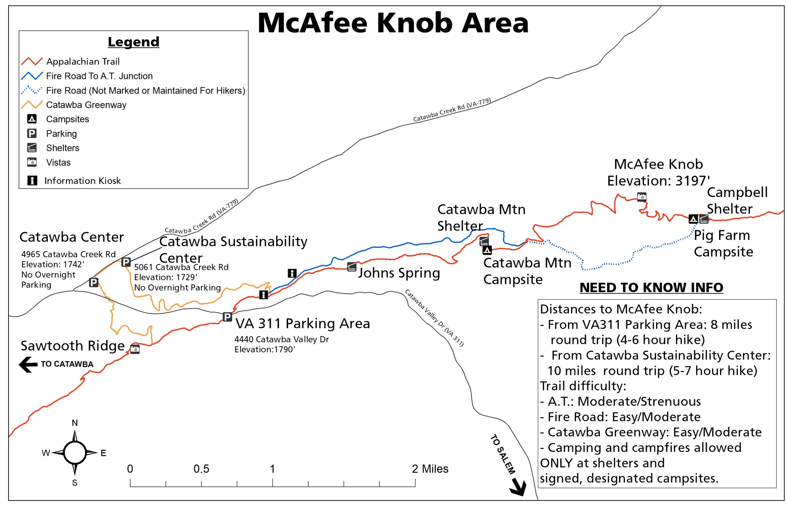