Roanoke, Virginia, is the largest city adjacent to the Blue Ridge Parkway, and one whose popularity and growth has certainly paralleled that of the park. It grew rapidly from its origins as Big Lick when, in 1882, the railroad became the town’s major industry. The huge neon star on top of nearby Mill Mountain dates from the late 1940s, and was erected to celebrate the industrial and civic progress of the city. See the Roanoke River and the Niagara hydroelectric dam from the Roanoke River Overlook at milepost 114.9. At milepost 120.3, take the scenic road over Roanoke Mountain, a 4-mile one-way loop road that affords stunning views of Roanoke, Roanoke Valley, and Mill Mountain (sorry, no trailers allowed). Scattered at the convenient overlooks and parking areas are picnic tables and short, scenic leg-stretchers.
Please note :: there is a campground in the Roanoke Mountain Recreation Area, but it is closed and there is not set date for it to re-open.
Hiking Trails of Roanoke Mountain & River Valley
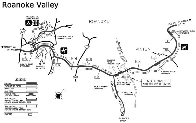
Download the Roanoke Valley trails map.
Roanoke River Trail
This .5-mile loop trail starts at the Roanoke River Overlook at MP 114.9.
Roanoke Mountain Loop Trail
This .4-mile loop trail departs from the top of Roanoke Mountain and is reached by the Roanoke Mountain Loop Road.
Buck Mountain Trail
This 1-mile round trip trail starts at the Buck Mountain Overlook and leads to a view of Buck Mountain and the city of Roanoke.