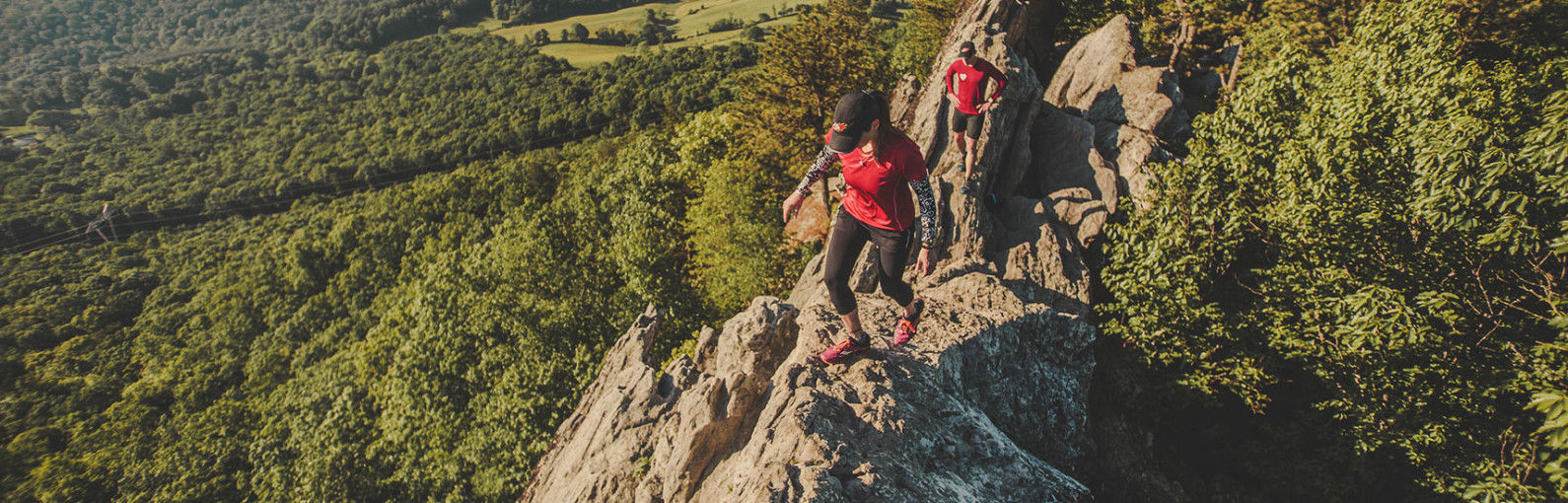

Roanoke Hikes
You don’t have to wander far from home to experience some of the best hiking on the East Coast, with dozens of trails right here in Roanoke. Chances are there’s a trail head within a few minutes of your location from anywhere in the city. So leave the asphalt, cars, and noise behind and lose yourself on one of these trails.
Not sure where to start? Here are three trails we know you’ll love.
- Carvins Cove Nature Reserve is the second largest municipal park in the nation. It holds a major water source within its 12,700 acres and overflowing recreational opportunities including hiking, biking, fishing, and boat rentals. The 11,363 acres of Carvins Cove is protected by the largest conservation easement in Virginia’s history. There are more than 40 miles of multi-use trails.
- The Explore Park Trail System, located off the Blue Ridge Parkway, is a 1,100-acre preserve situated along the Roanoke River Gorge with a variety of hiking options. Trail options ranging from less than one mile to 10 miles – many of which are loop trails.
- Read Mountain is a 243-acre Roanoke County park with a 3.8-mile round trip out/back hike from the parking lot to the Buzzard Rock summit. This is a moderately difficult hike and you are rewarded with a spectacular view of the valley from the summit.
Find Your Trail
Roanoke Hikes
-
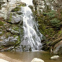
Bottom Creek Gorge Preserve


 Forming the headwaters of the Roanoke River, Bottom Creek Gorge boasts spectacular scenery including the second highest waterfall in Virginia, virgin hemlocks, and hundreds of wildflowers.
Bottom Creek is a powerful mountain stream that forms a stair-step series of broad-basin waterfalls known as the “kettles.” One of the headwater streams of the South Fork of the Roanoke River, Bottom Creek boasts a 200-foot high waterfall. Flanking Bottom Creek are forests of mixed hardwoods (tulip poplar, maple, oak, hickory) and upland meadows. Five rare species thrive in this habitat.
NOTE: Dogs are not permitted at Bottom Creek Gorge Preserve.
-
Buck Mountain Trail
Buck Mountain Trail is a very short trail that takes you away from the parking lot and instantly into a virtually untouched spot in nature. There are rocks to climb, trees to explore and wonderful spots to sit and listen to the birds around you.
Buck Mountain Trail is located in the upper parking lot of Roanoke Mountain Loop Road, located off the Blue Ridge Parkway at Milepost 120.
-
Carvins Cove Natural Reserve
Carvins Cove Natural Reserve is the second largest municipal park in the nation. It holds a major water source within its 12,700 acres and overflowing recreational opportunities including hiking, biking, fishing, and boat rentals. The cove includes 11,363 acres that are protected by the largest conservation easement in Virginia’s history.
With more than 60 miles of trails and an 600-acre reservoir Carvins Cove is a mountain biking, hiking, horseback riding, fishing, and boating paradise.
- There are three entrances to the Cove:
-
Chestnut Ridge Trail
The Chestnut Ridge Trail is located along the Blue Ridge Parkway. It is a wide and well-graded path lined with mountain laurel and rhododendron and includes a 5.4 mile figure-eight loop trail that can be shortened to 2.5 or 3.4 miles.
The easy to moderate trail is just 10 minutes from Downtown Roanoke and is also adequate for horseback riders.
-
Dismal Falls
 Dismal Falls is a 15-foot, multi-tiered waterfall on Dismal Creek. It is easily accessed from the road or from a side trail off of the Appalachian Trail.
Dismal Creek is about 50 feet wide (depending on water volume) at this point as it flows down over several ledges. The ledges on the left side of the falls are step-like while the middle and right ledges are more of a straight drop. In lower water, the middle and right are not covered and the stream is much narrower. Despite the width of the stream, the waterfall is not particularly open with trees lining each bank and throwing much of the falls into shade most of the day.
-
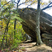
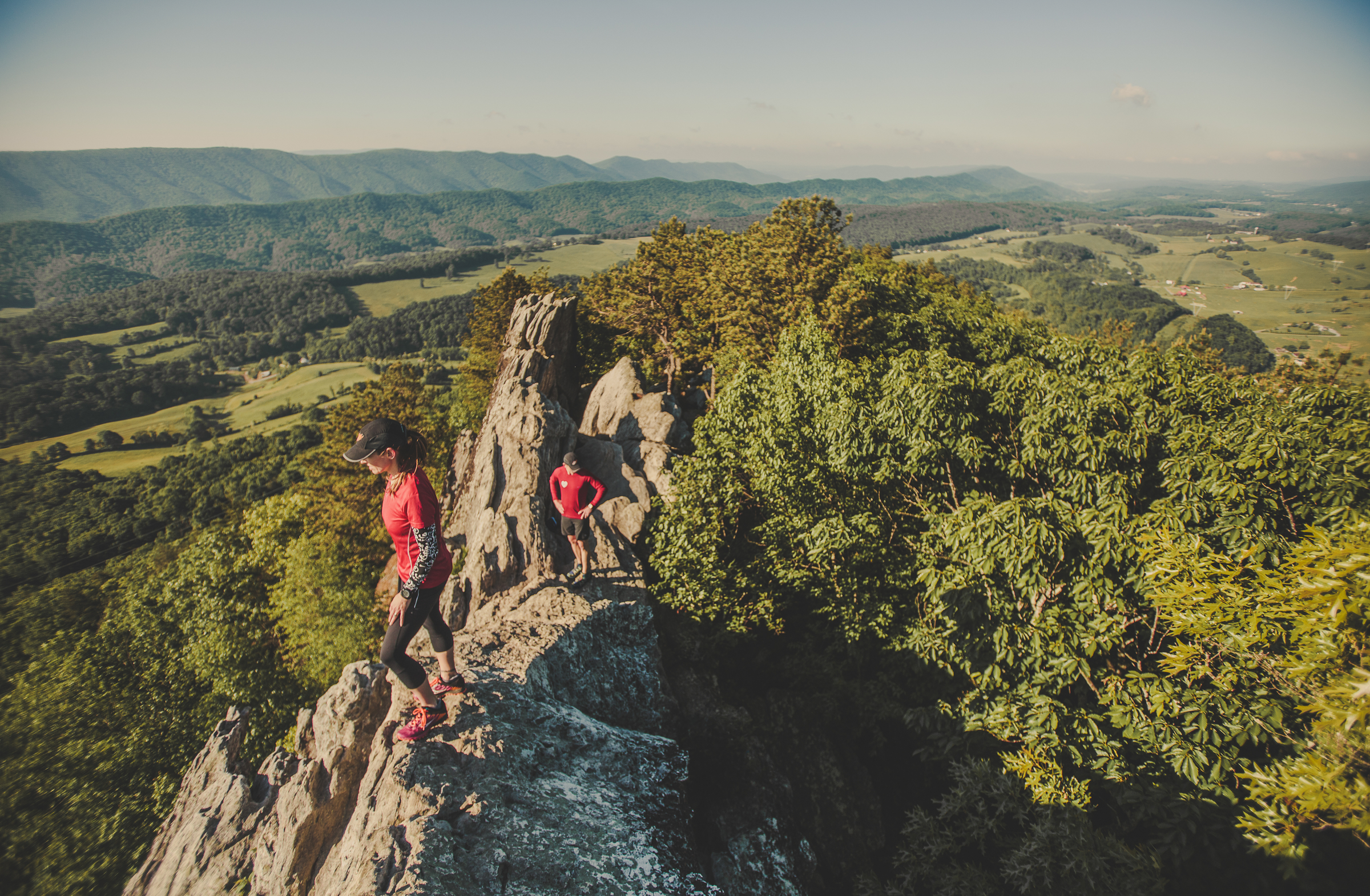
Dragon’s Tooth
Dragon’s Tooth is a unique geologic feature that consists of
 Tuscarora quartzite spires which outcrop on the top of Cove Mountain. The tallest “tooth” projects roughly 35 feet above the surrounding rock. The trail to Dragon’s Tooth ascends steep, rugged outcrops of quartzite which form the spine of Cove Mountain and North Mountain. The spine is known as Dragon’s Back.
Note: The Dragon’s Tooth hike is one of the most popular hikes along the entire Appalachian Trail and sees a tremendous amount of hiker traffic. The trailhead parking lot (Rt. 311) has limited space; DO NOT PARK on Rt. 311 – YOU WILL BE TOWED. It is ideal to hike this on a weekday as weekends are very crowded. Vehicles not parked in the parking lot are subject to tow. Please read specific rules and regulations at the bottom of this description.
Hike Description
- ~ 4.5 mile round trip, out and back hike.
- Moderate to difficult.
- 20 minutes from downtown Roanoke.
- Map kiosk at trailhead (very straight forward hike). Take a picture of the map so you have it on your phone.
- The trail starts with a kiosk at the back of the parking lot. You will follow the blue-blazed trail to the very top.
- Go 0.25 mile and cross two small bridges.
- You’ll see the intersecting yellow-blazed Boy Scout Connector Trail. Bear right and continue on the blue-blazed trail.

- Continue for nearly 1.5 miles, crossing the creek several times on a steady incline before reaching the Appalachian Trail intersection.
- Turn right to go south on the white-blazed Appalachian Trail. There will be 0.7 miles of steep rock steps before bearing left at the intersection to follow the blue-blazed trail to Dragon’s Tooth.
- Come back the way you went up, or once you reach the Appalachian Trail, go beyond the blue-blazed trail you started on and continue north on the A.T. until you reach the yellow-blazed Boy Scout Connector Trail. You’ll go left on this trail until you reach the blue-blazed Dragon’s Tooth Spur Trail, and go right toward the parking lot. This second route back offers different scenic views.
Directions to Trail Head
- From Roanoke – take I-81 south to Exit 141. Turn left at the traffic light onto Rt. 419 (Electric Rd.) and follow 0.4 miles to next traffic light (Rt. 311). Turn right onto Rt. 311N and follow for 10 miles. Dragon’s Tooth parking lot is on left just past Catawba Grocery.
Rules & Regulations
- Max. group size for day hikes is 25 people.
- Max. group size for backpacking/camping is 10 people.
- No alcohol
- Bring lots of drinking water
- Bring a flashlight as groups often lose track of time and are hiking back in the dark
- Dogs must be on leash at all times (be aware there is a section where you will have to lift your dog up a 6′ wall)
- No camping or campfires on Dragon’s Tooth, McAfee Knob or Tinker Cliffs
- Practice Leave No Trace
- Pack out all trash
- No camping or campfires outside of the 7 designated shelters/camping areas.
- Visit local A.T. C. Club for more details.
Add On
- Finish your day with a great meal at the Home Place – a restaurant famous among thru hikers. To reach the Home Place, continue north on Rt. 311 for ~1 mile to a large white farmhouse on left.
- Grab a beer at Parkway Brewing Co.
- Go see a baseball game! Click here for Salem Red Sox schedule
-
Greenways
 Greenways are open-space corridors reserved for recreational use or environmental preservation that connect urban centers.
Most greenways can be found along rivers, across ridgelines and along other scenic or historic routes. These spaces often have hiking or multi-use trails, which help link Roanoke’s natural beauty to its charming neighborhoods and vibrant downtown. There are more than 30 miles of greenways throughout the Roanoke Region.
-
Hanging Rock Battlefield Trail
 The historic Hanging Rock Battlefield Trail offers a touch of local and national history, as well as a pleasant place to walk off lunch. Many wildflowers grow along the trail.
A simple cinder trail winds along the edges of Mason Creek. This rails to trails form allows for quiet solitude away from the traffic. The trail is popular with walkers in the afternoon. Look for falling rock, historical markers, and flowers and berries.
-
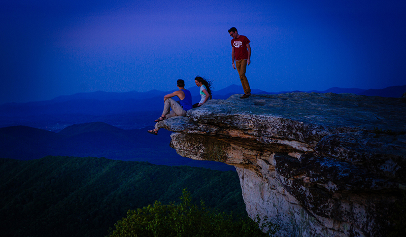
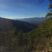
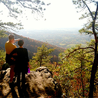
McAfee Knob

McAfee Knob is the most photographed site along the Appalachian Trail. The knob has an almost 270-degree panorama view of the Catawba Valley and North Mountain to the west, Tinker Cliffs to the north and the Roanoke Valley to the east.
UPDATE: The trailhead parking lot on Rt. 311 will be fully (as in 100%) closed for 12 months, beginning 11/30/2023, while construction of a pedestrian bridge across Rt. 311 is built. Only the parking lot will be closed, the Appalachian Trail will remain open. Click here for a list of alternative parking options. You will be ticketed/towed if you park along Rt. 311. Carpooling is recommended.
Note: The McAfee Knob hike is one of the most popular hikes along the entire Appalachian Trail and sees a tremendous amount of hiker traffic. DO NOT PARK on Rt. 311 – YOU WILL BE TOWED. It is ideal to hike this on a weekday as weekends are crowded. Click here for a list of alternative parking options.
McAfee Knob Trailhead Shuttle: Avoid parking headaches by utilizing the McAfee Knob shuttle service. This seasonal shuttle runs every Friday, Saturday, and Sunday, with the occasional holiday Monday. The 2024 shuttle season runs March 1, 2024 through November 26, 2024. The shuttle departs every 30 minutes from Park & Ride at I-81 Exit 140. New for 2024, additional on-demand shuttle stops include downtown Salem, Orange Market, and Dragon’s Tooth trailhead – Learn more and reserve your spot.
Trail Description
McAfee Knob is one of three hikes that make up the Appalachian Trail Triple Crown in Virginia. This overnight backpacking trip begins and ends at the Route 311 Appalachian Trailhead. This is a difficult hike totaling about 32 miles and includes McAfee Knob, Tinker Cliffs, and Dragon’s Tooth.
- Approximately 7.5 miles round trip.
- Allow 4-6 hours for full roundtrip hike.
- The trail begins on the opposite side of Rt. 311 from the parking lot. Cross Rt.311 with caution. You will travel north on the Appalachian Trail on to McAfee Knob. Follow the white blazes – which are 6-inch rectangular paint marks placed periodically on trees at eye level.
- After ~0.3 miles you will come to an informational kiosk.

- You will cross four wooden walkways before reaching the Johns Spring shelter. You will then cross five more wooden walkways before reaching the Catawba Mountain shelter.
- Next, you will cross an old fire road and a power line clearing. Continue 0.5 miles further and turn left onto the McAfee Knob spur trail to arrive at the lookout in ~30 yards.
- Retrace your steps or turn right once you reach the alternate fire road for your return trip.
Rules & Regulations
- Maximum group size for day hikes is 25 people
- Maximum group size for backpacking/camping is 10 people
- Bring lots of drinking water
- Bring a flashlight as groups often lose track of time and are hiking back in the dark
- Dogs must be on a leash at all times
- No camping or campfires on McAfee Knob or Tinker Cliffs
- Practice Leave No Trace
- No camping or campfires outside of the seven designated shelters/camping areas
- Visit local A.T. Club for more details
Directions to Trailhead
From Roanoke – take I-81 south to exit 141. Turn left at the traffic light onto route 419 (Electric Rd.) and follow 0.4 miles to the next traffic light (Rt. 311N). Turn right onto Route 311N and follow 5.6 miles to the top of the mountain. The trailhead parking lot is at the very top on the left. Be careful turning into the parking lot as it is a semi-blind turn. Do not park on the side of Rt. 311, you will be ticketed and towed.
Add-on Adventures
- Grab a post-hike beer at Parkway Brewing Co.
- See a baseball game! Click here for the Salem Red Sox schedule.
-
Mill Mountain Park
Less than 5 minutes from downtown Roanoke, Mill Mountain Park offers incredible mountain biking (9 miles) within 5 minutes of downtown Roanoke. The trails encompass Roanoke’s highest point – the summit of Mill Mountain (1,703 feet) and the Roanoke Star. This area offers 900 acres of parkland atop Mill Mountain, picnic areas, two overlooks that provide 20-60 mile vistas, access to additional hiking trails, the Mill Mountain Zoo, and Mill Mountain Discovery Center.
- Watch a video of mountain biking on Mill Mountain
- See live video from the StarCam
- Download a Mill Mountain Park Trail Map
-
Poor Mountain Natural Area Preserve
 Poor Mountain Natural Area Preserve protects the world’s largest population of the globally rare shrub piratebush, which is restricted to only a handful of sites in the mountains of Virginia, Tennessee, and North Carolina.
The “Wednesday Trail Crew,” a group of volunteers with the Roanoke Valley Pathfinders, constructed more than 1.5 miles of the trail system at Poor Mountain.
Trails include a relatively easy 1-mile loop through the piratebush population (Piratebush Trail), and a steep and strenuous 4-mile loop (Canyon Trail). There are also two spur trails along the Canyon Trail that lead to a waterfall (Cascade Spur trail) and overlook vista (Overlook Spur trail).
Stone stairs, scenic vistas, fire ecology, and outstanding looks at Table Mountain pine woodlands make the Canyon Trail a great hiking experience. Hiking the loop in a counter-clockwise direction provides the easiest hike. Hike in a clockwise direction if you want more of a challenge.
-
Read Mountain
 Read Mountain is a 243-acre park in Roanoke County and one of the county’s largest passive recreation areas.
The park includes a 5-mile trail system with moderate to strenuous levels of difficulty. The main feature of the park is a 2-mile trail to Read Mountain’s summit, known as Buzzards Rock. The view from the top is one of the best in the Roanoke Region.
-
Stiles Falls
 Stiles Falls is a 40-foot waterfall located on Camp Alta Mons property. The trail is closed to the public while summer camp is in session.
The hike is about 3 miles long. From the camp office, walk up the road past the swimming pool, the retreat center, and the pond. Continue along the dirt road until you come to a sign indicating “Falls.” Follow the trail to the falls crossing the creek three times before reaching the falls. The trail is marked with white blazes.
-
Tinker Cliffs (Andy Layne Trail)
The 6.6-mile out and back hike on the Andy Layne Trail intersects with the Appalachian Trail and ends with incredible views.
From the trailhead, take the yellow-blazed trail for about 3.1 miles to the intersection with the Appalachian Trail. Turn right onto the white-blazed A.T. (southbound) and reach Tinker Cliffs within 0.75 miles. Enjoy the 180 degree view.
From 1,300 feet near the trailhead and creek crossings to just a hair under 3,000 feet at the cliffs. Bluff top views are the most prominent feature, but there are also nice creek drainages, intriguing rock formations, and lovely forests on the way. Even the part of the trail that goes through a cow pasture includes pleasant rushing streams and scenic views up toward surrounding ridges. Some tough, steep stretches as it rises 1,700 feet in elevation.
-
Tinker Ridge/Hay Rock Overlook
 Tinker Ridge Trail crosses Tinker Creek, which is the site depicted in Annie Dillard’s “Pilgrim at Tinker Creek,” then ascends Tinker Ridge at Hay Rock Overloook, providing spectacular views of Carvins Cove and the Roanoke Valley.
The 8-mile round trip hike on the Appalachian Trail is just 15 minutes from Downtown Roanoke and is of moderate difficulty.

Create Your Own Land Adventure
Get Started Powered by Roanoke Outside